 DatARA
biannually
Domaines
Harvested
Provided by
Type of resources
Available actions
Topics
Provided by
Years
Formats
Representation types
Update frequencies
status
Scale
Resolution
-
La BD CARTO® version 5.0 est la base de données cartographiques de référence. Utilisée de l'échelle départementale (1 : 50 000) à l'échelle régionale (1 : 250 000), elle décrit l'ensemble des informations présentes sur le territoire métropolitain et les départements et régions d'outre-mer. Les objets de la BD CARTO® sont structurés en thèmes : • Administratif ; • Bâti ; • Hydrographie ; • Lieux nommés ; • Services et activités ; • Transport ; • Zone d'occupation du sol ; • Zones réglementées. Dans la version 5.0, tous les objets possèdent un identifiant unique et stable dans le temps.
-
La BD CARTO® version 5.0 est la base de données cartographiques de référence. Utilisée de l'échelle départementale (1 : 50 000) à l'échelle régionale (1 : 250 000), elle décrit l'ensemble des informations présentes sur le territoire métropolitain et les départements et régions d'outre-mer. Les objets de la BD CARTO® sont structurés en thèmes : - Administratif ; - Bâti ; - Hydrographie ; - Lieux nommés ; - Services et activités ; - Transport ; - Zone d'occupation du sol ; - Zones réglementées. Dans la version 5.0, tous les objets possèdent un identifiant unique et stable dans le temps.
-

La BDNB (Base de Données Nationale des Bâtiments) est une cartographie du parc de bâtiments existants, construite par croisement géospatial d’une vingtaine de base de données issues d’organismes publics. Structurée à la maille « bâtiment », elle contient une carte d’identité pour chacun des bâtiments, résidentiels ou tertiaires. La BDNB a vocation à être mutualisée et à constituer un référentiel ouvert, socle de développement de multiples services portés par des acteurs publics et privés, mais aussi lieu de capitalisation des connaissances sur les bâtiments existants.
-

Le produit SCAN EXPRESS IGN multi échelle regroupe les produits suivant : - SCAN EXPRESS 25 - SCAN EXPRESS 50 - SCAN EXPRESS 250 - SCAN EXPRESS 1000
-
Le produit POINT ADRESSE® V2.2 est une base de donnée vecteur 2D qui contient les adresses postales. La version 2.2 améliore la localisation des adresses par l'utilisation de la composante parcellaire du RGE®. Millésime 2018 - Données de mars 2018 (édition 18.1)
-
La BD TOPO® version 2.1 contient une description vectorielle 3D (structurée en objets) des éléments du territoire et de ses infrastructures, de précision métrique. Elle est livrée pré-symbolisée dans les formats propriétaires les plus courants du marché. Les objets de la BDTOPO® sont structurés en thèmes : - le réseau routier et son adressage - le réseau ferroviaire - le réseau de transport d'énergie - le réseau hydrographique - les bâtiments - la végétation arborée - l'orographie - la structure administrative - les points d'activité ou d'intérêt (PAI) - les toponymes de lieux-dits. Le processus de production 3D permet de fournir l'altimétrie des objets, ainsi que la hauteur des bâtiments. Le relief est décrit sous forme de modèles numériques de terrain (MNT). Dans la version 2.1, tous les objets possèdent un identifiant unique et stable dans le temps. Millésime 2013 - données d'octobre 2013 (édition132) La licence de droits d'usage est cofinancée par l'Union européenne.
-
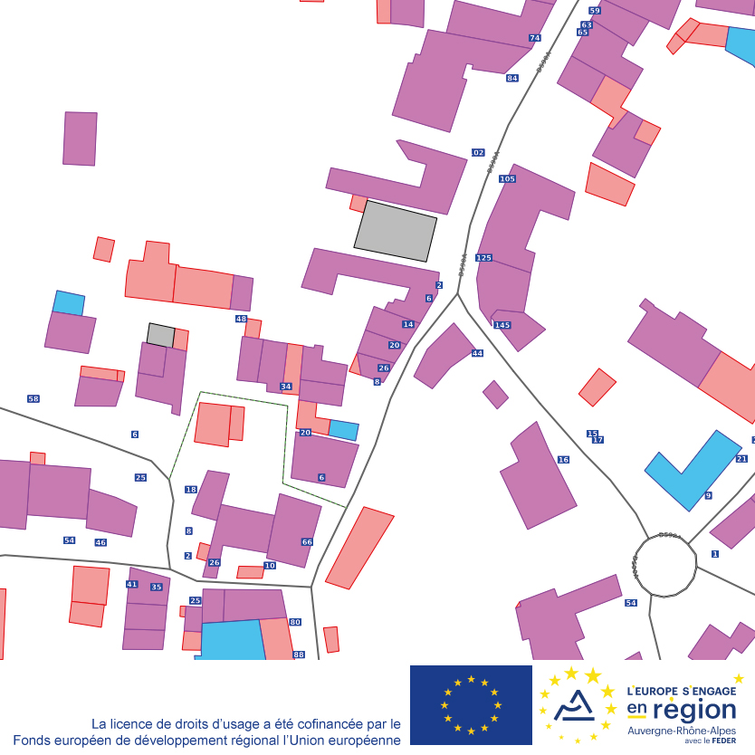
Le produit ADRESSE PREMIUM est un produit complémentaire aux bases de données de l’IGN. Le produit est composé des thèmes suivants : - A_PARCELLE qui contient des objets géométriques permettant de faire le lien entre les adresses de la BD ADRESSE® ou de POINT ADRESSE® et les parcelles de la BD PARCELLAIRE®. - B_BATI qui contient des objets géométriques permettant de faire le lien entre les adresses de la BD ADRESSE® ou de POINT ADRESSE® et les bâtiments de la BD TOPO®. - C_IRIS qui contient les tables attributaires sans géométrie permettant de faire le lien entre les identifiants des adresses de la BD ADRESSE® ou de POINT ADRESSE® et les identifiants des IRIS (Îlots de regroupement pour l’information statistique) de l’INSEE. - D_HEXA qui contient les tables attributaires sans géométrie permettant de faire le lien entre les identifiants des adresses de la BD ADRESSE® ou de POINT ADRESSE® et les codes Hexavia et Hexaclé de la Poste. Millésime 2019 - données d'octobre 2019 La licence de droits d'usage est cofinancée par l'Union européenne.
-
Le produit SCAN IGN multi échelle regroupe les produits suivant : - SCAN 25 - SCAN 100 - SCAN Régional - SCAN 1000
-
Pistes et Bandes cyclables (Savoie)
-
Extraction Géorisques au 1er janvier 2024 Les Atlas de Zones Inondables (AZI) sont élaborés par les Directions Départementales des Territoires (DDT) dans chaque département. Ils sont construits dans la plupart des cas à partir d'études hydrogéomorphologiques ou à partir des plus hautes eaux connues (PHEC), voire à partir des inondations de période de retour centennale à l'échelle des bassins hydrographiques. Ils sont rattachés au volet « gestion des risques » des SDAGE (Schéma Départemental d'Aménagement et de Gestion des Eaux), élaborés par les comités de bassins.